Last Sunday was the day to do a practice walk in preparation for the ‘real thing’ on Thursday this week (17th October) when it is my turn to lead the Thursday Walk for the Weekday Wanderers. In August I’d done a walk from Fountains Abbey but this proved rather uninteresting so I was inspired to try a different one to present to the group. Twice this year we have walked from Hetton around Winterburn Reservoir, with slight variations each time. Memories of the wonderful views across to Cracoe Pinnacle inspired my choice last week.
A friend, and fellow Wanderer, agreed to accompany me. In the past both of us had had difficulty finding one of the paths down to Cracoe but we felt that with both of us working on the challenge, and our previous experiences, we would find a suitable descent. And we did.

There are several versions of this walk but the one we finally decided on was from the Yorkshire Post – Rylstone Edge in the Saturday ‘Walk this way” series, 24 July 2010. [NB This walk is not listed on the link]

We parked by the picturesque duck pond in Rylstone (yes, yes, home of the Calendar Girls, remember them?) crossed the B6265 (Skipton to Grassington road) took the track past the Manor House to St Peter’s Church and from there headed across fields and along another decent track to the Access Point to Barden Moor and Barden Fell Access Area.

Map of the Access Area [property of the Bolton Abbey (Devonshire’s) Estate]

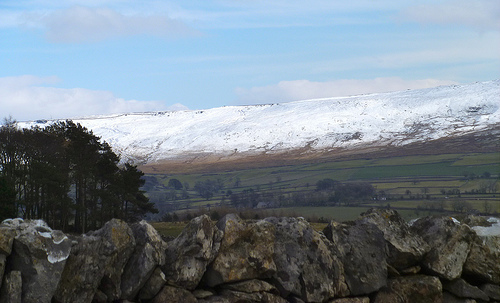
Looking back to St Peter’s and Rylstone

View near gate to Access Area
Through the gate we took the track which rose steadily until we were almost on a level with our first monument – The Rylstone Cross. A left turn took us gently up to the cross itself. This 1995 cross replaced the original 1815 cross that commemorated the Treaty of Paris near the end of the Napoleonic era.

Rylstone Cross

Between the War Memorial and the Cross [Memorial in middle distance]
From the cross, along the ridge, we kept to the eastern side of the dry stone wall until we reached the second memorial The Cracoe Obelisk War Memorial which records the names of those Cracoe men who died in the First and Second World Wars.

Cracoe War Memorial
It is the path down to Cracoe that has proved elusive in the past and you run the risk of ending up in very marshy ground which is impossible to pass through. This time we managed to find a good clear route and emerged from the least marshy area at some old sheepfolds on the edge of Cracoe village at the top end of Fell Lane.

The old sheep pens and war memorial
The lane leads down to the village which is where you leave the Access Area. And here the big disappointment was revealed – the whole area is closed to the public on a list of 14 days between the end of September and the end of October and one of these is Thursday 17th October!! So, having negotiated a perfect route for a day out with superb views across the Yorkshire Dales the walk will have to be shelved until next year at the earliest.

Access Area Information Board – Study Carefully!
The final walk back to the car was along a quiet track (Chapel Lane) behind the village and parallel with the main road past St Peter’s Church, Rylstone again and so back to the car. Looks like I’ll turn back to the uninspiring walk from Fountains Abbey for next Thursday 😦 .

Grrrrr!!!!

Oh dear – we once had a very severe telling off for wandering on the grouse moors near Blubberhouses. I hope they don’t shoot the White Doe!
Ah, yes, Nilly. I forgot about that poem of Wordsworth’s, thanks for the reminder!
http://www.bartleby.com/145/ww341.html
What bad luck. Maybe your Fountains walk will be better than expected….autumn colours??
That’s the spirit, Fran, ‘always look on the bright side of life’, thank you!
It looks beautiful. I’m fascinated by the cross for the Paris Treaty. Was there some local reason for having it there, or did lots of places have a memorial to mark the end of the Napoleonic Wars? I know many men must have been killed and maimed, and I’ve come across accounts of homeless, jobless soldiers/sailors who roamed the countryside after they returned to England, so there must have been a huge impact on communities, but I don’t remember ever coming across anything like this before.
Christine, I have no idea, my information was drawn from the notes that accompanied the walk description. I really should try to find out more.
The woods beyond our road “unofficially” close at the beginning of deer season (remember the deer blinds throughout?), so yet another reason to head into the city (apart from 30-degree temps at night). Is this a big caving (“potholing”) area? A harrowing experience while at Lancaster, and it seems like it was that general region.
Well, I remember seeing deer around which I never have done before. But I didn’t realise that there’s a shooting season for them! In the case of Barden Moor it’s grouse but new ‘right to roam’ legislation may restrict this further. The pot-holing areas are a bit further into the Yorkshire Dales but you are right – this the area you’d have had that harrowing experience in!
[…] back to the Barden Moor Access Area practice walk a couple of weeks ago I’m pleased to announce that the alternative walk, which […]