Christmas in Black and White and Colour

2014 tree

Compliments of the Season to Everyone.

Two weeks ago I slipped on black ice and fractured my right wrist. This is severely limiting my typing ability and posts will be very intermittent for a while.

However, I’d like to share pictures of the lovely gifts I received this Christmas. As often happens they fall into themes. Each gift has been especially and thoughtfully chosen with ME in mind. I could not have chosen better myself.

black and white

Black and White Gifts

tea tray

Tea Related Gifts (although someone thinks I’d rather be drinking wine!)

london books

London Books, DVDs and Walk Map

I enjoy London walks and exploring the Hampstead and Belsize Park areas when I’m walking my son’s dog. I have the original Quiet London book and it has now spawned three more. I’m happy to spend the next weeks planning future explorations in London.

I’ve read W G Sebald‘s ‘The Rings of Saturn’ and seen this film. I’m looking forward to watching ‘Patience (after Sebald)’ again. Much of it is filmed in East Anglia where ‘Max’ Sebald lived and was professor at the University of East Anglia in Norwich. Sadly, when his very original writing was taking he off, he was killed in a motor accident near his home in 2001.

patience

Moi and MA

A story about a Pug called Moi set at Versailles

Alfie at Gif

Alfie at Gif-Sur-Yvette

We took my son’s pug with us when we stayed at the Windsor’s place near Versailles in 2012. In addition I had other smellies; plus a box of cards for me to write my thank you notes – if I can manage that this year!

smellies

smythson

My thanks to everyone for these special gifts!

The Head of Nidderdale

map

Today’s Dalesbus Walk took us right up to the head of Nidderdale where we took the circular path around Scar House Reservoir then climbed over to the hilltop village of Middlesmoor. Two of us then took the footpath down to Lofthouse where we caught the bus back to Pateley Bridge.

Main Street Pateley Bridge

Pateley Bridge on Sunday morning

SUNDAY 7TH DECEMBER: THE HEAD OF NIDDERDALE
Explore the wild and remote country at the head of Nidderdale before finishing in one of its highest villages.
Start: Scar House Reservoir: 11.25
Finish: Middlesmoor: Approx. 15.00
Distance/Grading: 6 miles / Moderate
TRAVEL: Outward: Bus 823/825 from Pateley Bridge (10.50).
Return: Bus 825 to Pateley Bridge, Harrogate and beyond for onward connections.
Walk Leader: Jim

Ornate waterworks

Setting off over the Scar House Dam in bright sunshine

We experienced all weathers as we circled the Scar House Reservoir which forms part of the Bradford water supply. A huge building project and feat of engineering around the end of the 19th and beginning of the 20th century sent water from the Nidderdale reservoirs (by gravity only – no pumping) to the city of Bradford and supplied work for hundreds of navvies :

Scar House Reservoir, Upper Nidderdale
Work on Scar House Reservoir began on 5 October
1921 and took 15 years to complete. Developing
such a vast scheme changed the landscape of Upper
Nidderdale for ever. Less than 100 years ago the
site was a noisy and dangerous work site buzzing
with activity. Huge amounts of manpower had to
be drafted in to build the reservoir and as a result a
whole village was created.

Peaceful Scar House
Now Scar House is characterised by its peace and
solitude. You can still see the remains of where the
village once stood and the landscape is scarred
by the old quarries and railway lines. With a bit of
imagination you can picture the thriving community.

[source]

Scar House sudden weather change

Weather can change suddenly!

It’s amazing to think that water piped from here eventually ends up in the taps of houses over 40 miles away by road.

The reservoir above Scar House is Angram also built to serve Bradford and completed in 1916.

Rough Angram waters

 Rough Angram Waters

Angram to Scar House

Scar House from Angram Dam

Luckily after crossing the Angram Dam there is a hut where we were able to shelter from the bitterly cold high winds to eat our lunch.

Sheltering from wind

Sheltering from the winds

View from hut

View from the hut

The walk continued to almost complete the circle round Scar House but we took a steep track (In Moor Lane – part of the Nidderdale Way) away from the reservoir and headed up and over the ridge to arrive eventually at the tiny hilltop village of Middlesmoor and the welcome log stoves and open fires of the Crown Public House.

St Chad's

St Chad’s, Middlesmoor and view to Gouthwaite

St Chad's cross

St Chad’s Cross

The cross dates from the 7th century. It commemorates St Ceadda (St Chad) leader of Celtic Christianity in the north. He was the first bishop of Lichfield and he died in AD 672. It was placed here after being discovered during restoration of the church in the early 1900s.

Path to Lofthouse

Footpath – three-quarters of a mile – to Lofthouse

After warming up by the fire and with an hour to fill before the bus was to leave Middlesmoor I decided to explore the church, enjoy the view from it (one of the best in the country according to Colin Speakman who came along on the walk) and then to head down a further three-quarters of a mile to the lower village of Lofthouse where the bus picked us up in the gloomy dusk to bring us back to Pateley Bridge.

“One of the Loveliest Places Possible – Endsleigh” : an introduction

House closer

Today the original Endsleigh Cottage is a 16 bedroom luxury hotel.

“We saw yesterday one of the loveliest places possible – Endsleigh – the Duke of Bedford’s, about twenty miles from here”. Thus wrote Queen Victoria in her diary on 14 August 1856.

The result of the work of Humphry Repton and Jeffry Wyattville this truly beautiful estate on Devon’s border with Cornwall is still lovely today. It’s a private and secluded place which has been remarkably well-documented in the estate accounts still kept at Woburn Abbey home the Dukes of Bedford the original developers of Endsleigh.

The  Picturesque taste was popular in England between 1790 and 1840 and Endsleigh is one of its prime examples.

Repton first visited Endsleigh in 1809 and he encouraged the development of a more ‘natural landscape’ than the formality of Capability Brown. Repton proposed the buildings and Wyattville designed them. The main ‘cottage’ dates from 1810 and the subsidiary buildings 1812-1816.  Endsleigh was his first large scale work which was a collaboration with Georgina second wife of the 6th Duke of Bedford.

Whilst at Endsleigh I read her fascinating story in the book “Mistress of the Arts: The Passionate Life of Georgina, Duchess of Bedford” by Rachel Trethewey (Headline Review, 2003).

Endsleigh map

Within limits as a guest I could walk within the estate, down to the Tamar River and in the formal gardens close to the house. I also took tea one afternoon and enjoyed inspecting the various manmade features of the landscape which include a Swiss Chalet, a Shell Grotto and a Dairy. More about the Chalet and the Dairy in future posts.

Endsleigh map close-up

Stepping down the track from the house to the river a stream and muddy path made it impossible to go beyond the former swimming pool so I headed to the river bank and followed it downstream as far as possible. Eventually a notice on a gate prevents you going any further.

Former swimming pool

 The Former Swimming Pool

River Tamar

The peaceful River Tamar


Tamar path

River Tamar and Path heading downstream

I returned along the path until I found a track leading up, up, up the valley side to a footpath which I hoped might lead to the Swiss Cottage. It didn’t; but I did find the memorial stone commemorating the spot where the 12th Duke was found dead in 1953.

Memorial to 12th Duke of B

Memorial wording

I’d read about this tragedy in another book “Endsleigh: the memoirs of a riverkeeper” by Horace Adams and edited by Clive Murphy [Braunton : Merlin Books, 1994]. I had the impression that Adams spoke or answered questions about his long life working first for various Dukes of Bedford and later for the Fshing Syndicate that took over the ‘cottage’ when the Bedfords needed to raise Death Duties. Murphy just transliterated Adams’s words to the page.

Fishery Cottage

Fishery Cottage overlooking the Tamar Valley

I didn’t manage to get more than a glimpse of the Swiss Cottage but nearby is Fishery Cottage at one time the estate home of Horace Adams. It’s now up for sale. Horace would be staggered – by the price and by the elegance!

From the main drive it’s possible to go into the formal gardens that surround the Hotel. They are now still beautifully maintained by about half a dozen full- and part-time staff. I didn’t make a note of the numbers of gardeners during the Bedfords’ tenure but there were probably around 5o.

Shell Grotto

A rough path leads to The Shell Grotto set on a cliff high above the river.

The grotto

The Shell Grotto

House view

View of Endsleigh from Shell Grotto

With the rise of the Romantic Movement in the 18th century and the return of the great explorers, building grottoes became increasingly fashionable … Some took the form of artificial underground caves;  others were built above ground in some picturesque spot deep in the woods or overlooking a beautiful view. The chief ingredients remained the same. They must be dark, have water, preferably a cascade or spring and be decorated with shells and minerals. … The grotto at Endsleigh is a rather late example … It is believed that the original intention was for it to be decorated with shells and minerals from Devon and Cornwall. … Obviously this scheme was not carried out as the grotto is full of tropical shells and corals. … It has been lately carefully restored and other shells and minerals have filled the gaps where the originals had crumbled away.” Patricia, Viscountess Boyd, October 1984 [Adapted from the description in the grotto]

Garden bower

Tamar Valley from the Grotto

From the Grotto and formal gardens I returned to the main drive and behind the house are the former stables.

Stables

There’s a plaque in the stables commemorating the laying of the foundation stone by her four eldest sons.

Foundation stone

The Foundation Stone above the arch is nearly covered with ivy

Foundation stone words

There is an arboretum with little bridges crossing streams and which contains unusual trees from around the world. But after further garden exploration in the damp weather and on slippery footpaths with the light beginning to fade even in the early October afternoon it was a relief to take tea in the library at Endsleigh Hotel.

Time for tea

Time for Afternoon Tea

Our Town : From Peterborough, New Hampshire to London, England

OUR TOWN prog

The weekend after we arrived home from New England at the end of September I spotted a small listing in the newspaper for the play “Our Town” by Thornton Wilder. At first I thought the play was due to tour and was actually coming to Leeds but an online search proved fruitless so I checked the dates again and saw that it was showing at The Almeida Theatre in London during dates I was going to be  in town.

The notice had particularly caught my eye because the week before in Vermont we had made an excursion into New Hampshire from Brattleboro which is literally on the border between the two states. They are separated only by the Connecticut River.

Connecticut River

The Connecticut River

Bridge linking VT and NH

The Brattleboro Road Bridge Linking VT and NH

Our intention had been to visit a mountain we had seen on the previous day from another trip to Wilmington VT and the viewpoint at Hog Back Mountain.

Monandnock from hog back

 View from Hog Back Mountain – 100 Mile View

But when we arrived at Mount Monadnock the State Park Warden told us that, although it is the most visited mountain peak in the USA [A magnet for hikers, Monadnock is said to be the world’s third most climbed mountain, following Japan’s Mount Fuji and China’s Mount Tai.], we might find ourselves limited by time (it’s really a full day hike) and advised us to drive a few miles further to Miller State Park where it is possible to drive right to the top and take a shorter trail from the peak car park.

View from Miller

View from Miller State Park

Trail to hawk watch

Miller State Park is located on the 2,290-foot summit and flank of Pack Monadnock in Peterborough and is the oldest state park in New Hampshire. A winding 1.3-mile paved road leading to the scenic summit is open for visitors to drive in summer and on spring and fall weekends. Three main hiking trails ascend Pack Monadnock to the summit. The best known is the Wapack Trail, which is a 21-mile footpath that extends from Mt. Watatic in Ashburnham, Massachusetts to North Pack Monadnock in Greenfield. It is believed Native Americans named the area’s mountains, and that “pack” means little. On clear days views reach to Mount Washington, the skyscrapers of Boston, and the Vermont hills.”

Boston skyline

Boston Skyline just visible (slightly right)

Yes, indeed, it was amazing to see the skyscrapers of Boston on the horizon from a distance of 55 miles away!

This could be Mt Washington

Could this be Mount Washington?

We were fascinated by the Audubon Hawk Watch set up in a clearing. It reminded me of the Malhamdale Hills and Hawks Walk in July. Just like the RSPB The Audubon Society had set up an area with information boards, information table, binoculars and telescopes on tripods and staff and volunteers ready to answer questions and tell about the project. We felt very under-equipped!

Birds seen

Birds Spotted

Serious twitchers

A Serious Twitcher

owl to attract

Owl Decoy

As we left the park and drove back towards Brattleboro I suggested we stop at the town of Peterborough. A good friend and reader of posts here, Sarah, had told me some time ago about the pretty town which served as the inspiration for Thornton Wilder’s play “Our Town”.

Views of Peterborough

main st peterboro

Peterboro 1

Peterboro 2

Peterboro 3

Peterboro 4

Sarah's Hat Boxes

“We all grow up, we fall in love, we have families and we all die. That is our story”

And that is the story of “Our Town”.

Jervaulx Abbey – Thornton Steward – Cover Bridge Walk

Historic, tranquil, beautiful

It’s nearly 40 miles to Jervaulx Abbey near Middleham, North Yorkshire and Thursday morning dawned rather grimly with rain and dark clouds. It seemed a long way to drive in order to get soaking wet all day.

But the Weekday Wanderers were not deterred and we met as usual at 9am at The Grove Church Car Park and two cars – eight of us in all – set off northwards. The rain had stopped and I lead a very successful ramble:

Jervaulx Abbey – Thornton Steward – The Cover Bridge

“Easy walking  – no hills. Field and riverside paths plus a pleasant walk through parkland at Jervaulx. Distance – 7.5 miles. Car parking at Jervaulx (£1 in honesty box)”

Jervaulx ruins

The Abbey Ruins

I had for a long time I had wanted to do this walk – always attracted by abbey ruins and other features of the landscape. I copied the walk from a book of walks from the library over a decade ago and unfortunately did not make a note of the title and author. Some of the features had changed slightly – a hedge was now a fence and a stile now a gate – but the bulk remains the same and the route was easy to find.

a bit of blue sky

A Glimpse of Blue Sky

We always take it upon ourselves to do a “recce’ or “walk out” in advance of leading and I was only able to do this with a friend in August. Believe me the weather on Thursday was a huge improvement on The Saturday in August when we got soaked to the skin.

Wanderers

At Jervaulx we took the public footpath signposted To the Abbey but kept straight on through the park and fields of sheep to the lodge and gates at the far end. There we joined a small, quiet lane that crosses the River Ure (the river of Wensleydale) at Kilgram Bridge just after which we diverted from the lane to cross fields to arrive at Thornton Steward.

R Ure at kilgram bridge

River Ure at Kilgram Bridge

thornton steward

What a lovely and kind village Thornton Steward is! In August as we lunched on the village green the heavens opened and we rushed to the nearby bus shelter. There we found a bag of fresh damsons with the message – Please take these – free to good cooks – or words to that effect. We took them, shared them and left a message of thanks in the village noticeboard. There we read :

Notice

So we noted the Institute and the benches outside and decided that this was the perfect picnic place for the October walk.

TS Villag institute

Thornton Steward Village Institute

Teas inside

Please make your own teas

Ramblers Relief

The Ramblers’ Relief was also very welcome!

Sited around a small village green, the village enjoys a wonderful southerly aspect with views across the broad valley to Jervaulx Abbey, Ellingstring and Witton Fell. Sheltered from the north by the higher land towards Finghall, it is surrounded by fertile farmland including the interesting Manor Farm and Danby Hall.

St Oswald's

The small ancient church is situated on lower land a quarter of a mile away, and centuries ago may have been in the centre of the original settlement. The recently discovered thirteen hundred year old graves to the west of the present church suggest ancient settlement in the area.

The church

The “neat, Gothic structure” dedicated to St. Oswald was part of the [Ripon] Diocese and in the patronage of the Bishop of Chester in 1823. The Reverend John Ewbank lived in the fine vicarage in the village, and between 1917 and 1953 the ministry of the blind Reverend Swayne was well known throughout the Ripon Diocese. This church is one of the oldest and most attractive in the country, abounding in history and interesting architecture. The surrounding area is preserved for wild plant and animal life and is a haven of peace and solitude.

Fort Horn

Fort Horn

In 1815 the school was erected by Captain George Horn, Esquire, [builder of the folly, now a private dwelling, Fort Horn] when the population of the parish was two hundred and sixty five. He was the wealthy “gentleman” of the village and provided a neat School House for John Story the schoolmaster, and an endowment of ten shillings per annum for the education of the poor children of the parish.” [source]

Danby

Danby Hall

After make use of facilities and leaving our donations we headed west out of the village down the private track that leads to the ancient church and thence across the parkland of Danby Hall and out onto quiet lanes which eventually cross the River Ure again and soon after the River Cover (hence, the Cover Bridge). Bothe rivers join to become the Ure and we followed its banks for the final stretch back to Jervaulx Car Park.

River Ure near Cover Bridge

River Ure at The Cover Bridge

River near end of walk

River Ure near the end of our walk

OS Sheet 99

OS Sheet 99

On our walk out we had ice creams at the nearby Brymor Dairy but the majority vote was to head to Masham and the Theakston’s Brewery Visitor Centre where we actually sat outside in the warm sunshine at the end of a most enjoyable and varied walk.

Stake Moss – A Dalesbus Ramble

SUNDAY 12TH OCTOBER 2014: STAKE MOSS
Take a brisk walk across the top of Wharfedale to follow the Roman road down into Wensleydale.
Start: Causeway Moss Road Junction 12.10
Finish: Bainbridge approx. 15.40
Distance/Grading: 7 miles / Moderate
TRAVEL: Outward: Bus 800 from Leeds (09.50), Horsforth (10.10), Guiseley (10.22), Ilkley (10.45) and Grassington (11.35).
Return: Bus 800 to Grassington, Ilkley and Leeds for onward connections.
Walk Leader: Jim

Just the job after a wedding on Friday and family party on Saturday! I just needed to get out and enjoy a brisk walk after all that high living.

Gilbert Lane

Gilbert Lane at the start of the walk

Eight of us got off the bus at Causeway Moss Road Junction not far from Buckden but the bus took the strain of the climb so we only had a bit of additional uphill on Gilbert Lane before we reached the summit of Stake Moss. Then we had a steady tramp along very clearly marked track to Busk Lane from where we were soon steadily descending along Carpley Green Road and into Bainbridge which is clearly still resting on its laurels after the early July successful hosting of the Grand Départ of the Tour de France.

Buckden Pike

Buckden Pike from Stake Moss

Typical view

Typical Yorkshire Dales View between Wharfedale and Wensleydale

Our track

Our Track on a lovely October Sunday

To Carpley Green

We leave the main byway and head towards Carpley Green

Sheep on a wall

Sheep on a Wall

Descending into Wensleydale

Descending into Wensleydale

Carpley Green and Addlebrough

Carpley Green Farm and Addlebrough Ridge

Semerwater

Semer Water

Askrigg

Askrigg in Wensleydale

Virosidum

Beyond the two stone walls are the earthworks of Virosidum (Roman Town)

Wensley Walling

Dry Stone Wall Wensleydale Style

Sheep

Baa Baa Black Sheep

Descending into Bainbridge

Descending into Bainbridge

Bainbridge Signs

Bainbridge Welcomed Le Tour

Sheep on penny farthing

TDF 2014

Rose and Crown Bainbridge

The Rose and Crown, Bainbridge – no time to visit as our bus was due!

Strolling Hand in Hand with Romance

Perhaps I should mention first of all that the romance is all Daphne Du Maurier’s.

Walk details

I snipped this walk out of The Observer (I think it was) decades ago and at last I have had the chance to actually step it out for myself! I stayed at a B&B for five nights in Cornwall in the village of Tywardreath (pronounced “towerdreth”). Almost all my daytime hours on Friday, Saturday and Sunday were spent at Port Eliot Festival but on Thursday I was not required until the afternoon so decided to do the walk that morning.

I took the bus to Fowey and arrived back at Par Station to take the train to St Germans, which is where Port Eliot House and the festival are located, at about 1pm. Unfortunately the day started with rain but I was glad I’d set out and the weather improved as the day progressed.  I’ve added my photos to some of Christopher Somerville’s text and instructions.

Bodinnick car ferry

Bodinnick Car Ferry leaving Bodinnick for Fowey

Prinsendam

MS Prinsendam Cruise Liner in the Fowey Estuary

From car park (I took the bus from Par Station) descend steps into town. Bear left along Fore Streetand on to Bodinnick ferry. Cross to Bodinnick;

Old Ferry Inn

The Old Ferry Inn Sign near the Ferry

go up the street past St John’s Chapel.

St John's Chapel

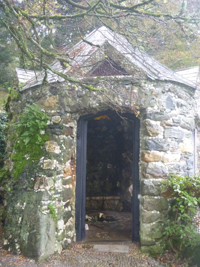
St John’s Church, Bodinnick

The little stone chapel stood back modestly from the village street, its dark interior cool as an icebox. The building had been a stable until  its conversion in 1948. In the chapel’s early days, its furnishings were primitive – worshippers were obliged to carry their own chairs down the lane to evensong.

Hall Walk

Go right above Old School House (sign “Hall Walk – Polruan 4 miles”); follow Hall Walk above Pont Pill [the muddy creek curls down between wooded hill slopes to join the River Fowey … Hall Walk follows the northern rim of the creek a couple of 100 feet above the water] for one mile.

Glimpse Fowey

A Glimpse of Fowey from Hall Walk

Boats bobbing

Boats Bobbing in the Fowey Estuary

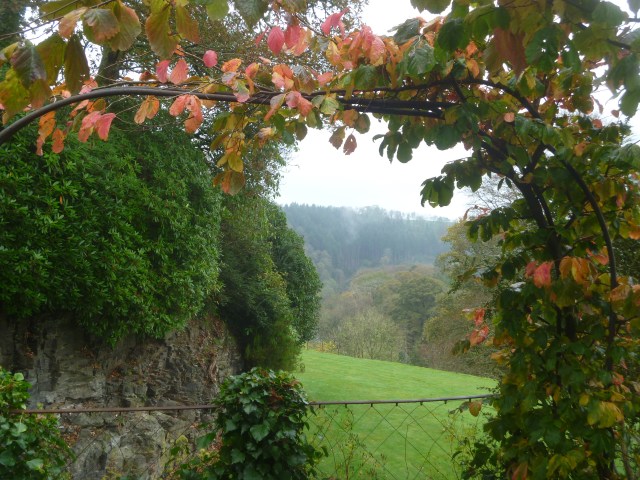
With the rain coming down luckily most of Hall Walk was covered over by trees with occasional glimpses of the creek below and now and again a viewpoint opened up to reveal the boats bobbing in Fowey harbour and estuary.

Q memorial

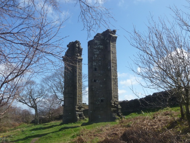
Cornwall’s grand monument to Sir Arthur Quiller-Couch, a tall granite monolith, faced another stunning view of Fowey, where the great Cornish-born man of letters lived for more than 50 years. Back in 1900, “Q” – as he was known – had edited his classic edition of the Oxford Book of English Verse. … “Courteous in manner,” the monument’s inscription eulogised, “charitable in judgment, chivalrous in action, he manifested in life as in literature the dignity of manhood, the sanctity of home and the sovereignty of God.”

Cornish stone stile

Cornish Stone Stile

When nearly opposite church tower, cross stile; follow wood edge for 150 yards; right across Cornish stone stile; down through woods following “Polruan” signs and over Pont Pill.

Pont Pill

Pont Pill with National Trust Holiday Cottages clustered around

Pass Pont Creek Farmhouse; up the path through trees to road. Left for 10 yards; right through gate (sign “Footpath to church”) to St Willow’s church.

Lanteglos church

St Willows Church Lanteglos

Here, after a boat ride up the creek, Daphne Du Maurier was married under the simple and beautiful wagon roof and the wide granite arches in 1932. St Willows also features as Lanoc Church in her first novel “The Loving Spirit”.

Barrel roof

The Wagon Roof, St Willows Church, Lanteglos-by-Fowey

Pew End

Close-up of Pew Ends

Left opposite Churchtown Farm to road. Right for 150 yards [now a field path that avoids walking on the road]; left (fingerpost “To the Coast Path” to cliffs. Right on coast path for one-and-a-half miles to road in Polruan. 

Looking back

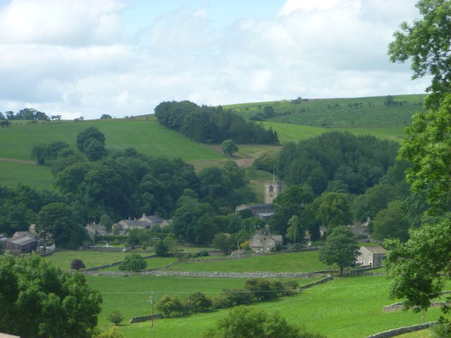
Looking back to the church, Hall Walk woods and Fowey

To Coast Path

The coast path walk is part of the national trail – The Southwest Coast Path. The rain had stopped by this point but the skies were still overcast.

Beach and Lantic Bay

Lantic Bay from the Coast Path

From SW Coast path

View from Coast Path near Polruan

Left down School Lane; right at bottom to road; left to Fowey Ferry. Cross to Fowey; climb to the Esplanade; turn right into town. I then had a stiff walk uphill to the bus stop with only seconds to spare. Luckily for me the bus was a few minutes late arriving but I still managed the train with time to spare.

Polruan Passenger Ferry

The Polruan Foot Passenger Ferry Approaches

OS Map

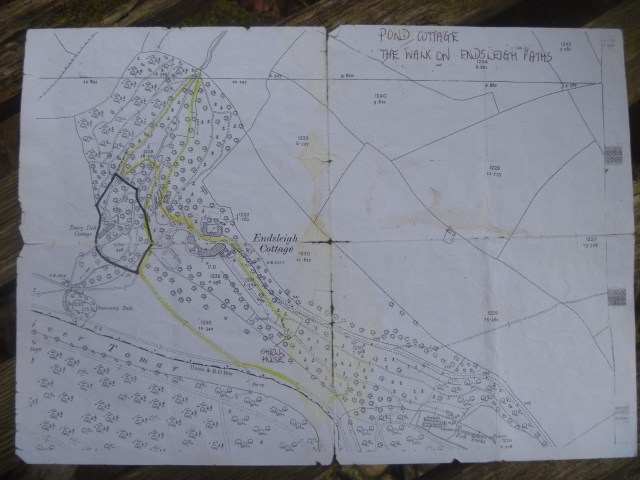
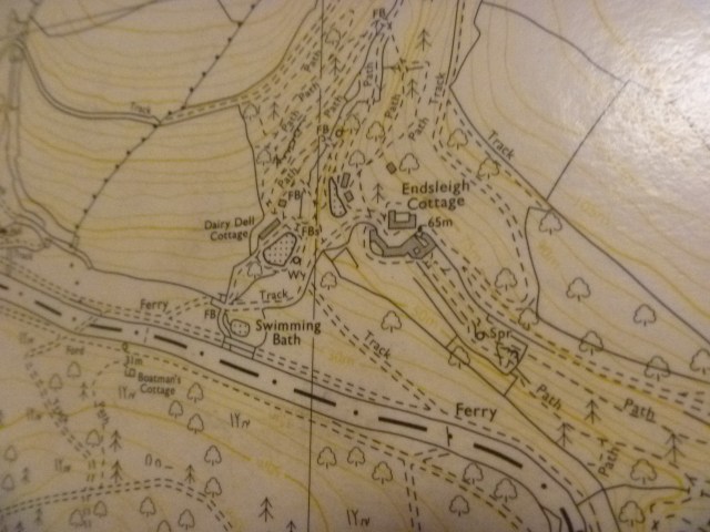
Map Showing Places Mentioned

Ampleforth Abbey Round

Abbey

“The monks of the Abbey of St Laurence live a life inspired by the Rule of St Benedict based in a beautiful valley in North Yorkshire. St Benedict emphasised the importance of community living as a context for the growth of the individual.” [website]

ST benedict

St Benedict Sculpture by Judy Brown

Ampleforth Abbey has been home to a community of Benedictine monks since 1802. It provides: a co-educational day and boarding school for ages 13 to 18; hosts retreats, pilgrimages and time for reflection; is home to St Martin’s a co-educational day and boarding school for ages 3 to 13; welcomes visitors wishing to spend the day there and provides refreshments in its Tea Room. St Alban’s Sports Centre provides excellent sport and recreation facilities and is open to the public and the Abbey produces and sells its own cider, beer, and other monastic produce and provides unique holiday lettings.

“The walk is approx 7 miles in N Yorks Moors Western Area with afternoon tea option at Ampleforth Abbey.”

That was the brief message about the Weekday Wanderers‘ Walk today.

Good Samaritans

The Good Samaritan by John Bunting

It’s nearly a year since I had my day out with friends visiting The Plot and I was reminded of this as we walked down from the car park through the Abbey grounds to begin our walk.

Mill Lane Sign

Walk this way


Abbey from field

 The Abbey from the Field Track

From here we headed along the lane and into Ampleforth village itself before heading south on field tracks to the wooded area surrounding the Lower Fish Pond.

Lower Fishpond

 The Lower Fish Pond

From here, through the woodland, we had a steepish climb up, up, up to a track along the ridge which eventually opened out into ‘The Avenue’ a broad avenue with woods on either side which was the approach at one time to Gilling Castle.  Lunchtime!

The Avenue

The Avenue

Ampleforth College Golf Club occupies the grounds of the Castle and our route took us around these immaculately kept greens eventually dropping down into the village of Gilling East.

Gilling Church

 Holy Cross Church, Gilling East

We had the opportunity to look round the Holy Cross Church before moving through the village and past the HQ of the Ryedale Society of Model Engineers where members were hard at work.

Boys Toys

Boys and their Toys

Passing over rough meadow land we arrived at a wheat field which we waded through following a very narrow public footpath. A sculpture of a man by Anthony Gormley (old boy of Ampleforth College) overlooks the local countryside here.

Gormley

Gormley Man

We were soon back in the College grounds and a tarmac track lead back up to the main buildings and the very welcome Tea Room.

Tea Room

Tea Room with local Mouseman furniture

Tea

Pear and Almond Cake nearly finished after a lovely day’s walk and visit

Malhamdale Hills and Hawks

It’s probably a few years since I was last up in Malhamdale so yesterday I was happy to join another Dalesbus Ramblers ramble there. The forecast was for showers but luckily not a drop fell.

RSPB sign

“Walk through Malhamdale’s finest limestone areas and maybe see its resident peregrine falcons.”

Start: Kirkby Malham 11.20
Finish: Malham approx. 15.30
Distance/Grading: 7 miles / Moderate
TRAVEL: Outward: Bus 875 from York (09.00), Knaresborough (09.40), Harrogate (09.55) and Skipton bus station (10.45).
Return: Bus 875 to Skipton, Harrogate and York for onward connections.

I joined the 875 bus at Harrogate Bus Station at 9.55 with my Metro Bus Pass and enjoyed the journey to Kirkby Malham thankful that I was not driving along the narrow twisting lane between Gargrave and Kirkby Malham myself.

Six of us set off from Kirkby Malham up, up, up through the hamlet of Hanlith joining the Pennine Way from where we gained wonderful views back to Kirkby Malham and ahead to Malham Cove.

Kirby Malham

Looking back to Kirkby Malham

Malham Cove from PW

Malham Cove and River Aire from the Pennine Way

We left The Pennine Way as it headed directly to the village of Malham and joined a popular footpath to Janet’s Foss. On entering the National Trust woodland area within which is the waterfall I noticed a sign telling about the Bee Library. I have seen one of these before at The Yorkshire Sculpture Park so knew what to look out for in the trees.

Bee Library


Malham Bee Library

A Malhamdale Bee Library

We also saw the Coin Tree.

Money tree

People have hammered copper coins into this dead tree trunk near Janet’s Foss waterfall for good luck for many years, and if you look closely you may find some very old pennies. This should never be done on a living tree as the coins will poison it. In Yorkshire we look after our pennies (because ‘the pounds then look after themselves’) so perhaps there is something to this tale! ”

Janet's Foss

Janet’s Foss

The Foss was crowded with visitors and there were even some brave (or foolish?) swimmers in the pool under the waterfall. Nevertheless we ate our lunch watching the world go by and then crossed the nearby lane and headed for Gordale Scar.

Approaching Gore Dale Scar

Approaching Gordale Scar

Goredale scar

Climbers were out on the rocks and on the cliff face and the bird spotters amongst us pointed out just one Peregrine Falcon circling in the sky above the Scar.

Climber

Climber at Gordale Scar

Retracing our steps to the lane we then climbed up to the plateau above Malham Cove where we crossed the clints and grykes of the Limestone Pavement. The clints are the blocks of limestone and the grykes are the gaps in between.

Limestone Pavement

Approaching the Limestone Pavement Above Malham Cove

Clints and Grikes

Limestone Pavement – Clints and Grykes

There are nearly 400 steps to tackle to get down to the bottom of the Cove and the steps were busy with folk going up and down. Apparently Malham Cove features in the film Harry Potter and the Deathly Hallows. Potter is seen camping at Malham Cove and scenes were filmed all around Malham including the Cove, the limestone pavement, Malham Tarn and Gordale Scar. Hence the large numbers of visitors.

Malham Cove

When you get to the valley bottom the RSPB have set up their Malham Peregrine Watch complete with information table, binoculars on tripods and staff and volunteers ready to answer questions and tell about the project. We spent about twenty minutes looking and listening but no peregrines were prepared to perform for us at the Cove that afternoon.

View here


Peregrine Searching

Peregrine Watch

Demonstration

Sue, the RSPB officer, shows us the approximate sizes of male and female peregrines (male is smaller)

Finally we rejoined the Pennine Way, this time heading south, into the village of Malham where I enjoyed a welcome pot of tea and slice of Yorkshire curd tart before joining the bus back to Harrogate and thence home.

Leaving Malham Cove

Leaving Malham Cove with the Crowds

Malham signpost

Interesting to be reminded that Malham (now in North Yorkshire) was once in the West Riding of Yorkshire


The Gems of Bewerley Village, Nidderdale

SUNDAY 8TH JUNE 2014: THE GEMS OF BEWERLEY VILLAGE
After discovering some interesting facts about this beautiful village we climb to join the Nidderdale Way before returning via field and woodland paths.
Start: Pateley Bridge, Bus Stand 10.50
Finish: Pateley Bridge approx. 15.30
Distance/Grading: 4.5 miles / Easy to Moderate

Last Sunday's walk

Nidderdale is my new favourite rambling region so I was happy to join fellow members and supporters of The Dalesbus Ramblers last Sunday for a shortish walk full of interest.

From Pateley Bridge it was a short walk to Bewerley where we stopped to study the local stone mason’s work – a depiction of the major features of the village carved in stone.

Stone carving of Bewerley

The Stone Mason’s Work. Frank explains the Latin Motto.

“soli deo honor et gloria” Honour and Glory to the only God.

Yorkes Folly picked out

Yorkes Folly picked out in stone


Leaving Yorke's Folly

Yorkes Folly for real (on a previous walk)

“Built around 1810 the folly was constructed by labourers working for John Yorke of Bewerley Hall. He commissioned the folly during a depression to keep his labourers in work and above the poverty line. Each labourer was paid a shilling a day and an loaf of bread. The folly was known as Three Stoops until a violent storm during the night of 17th November 1893 blew one of the towers down. Today it is known locally as the Two Stoops.” [Information Board at the folly]

Further along through the village we arrived at The Chapel of Ease.

“A small grange chapel of Fountains Abbey built by Marmaduke Huby which has remained intact. The Chapel was fully restored for worship in 1965. The chapel is open during daylight hours. We have services on the first and third Sundays of the month at 9am.”

Latin motto

Our leader Frank showed us the Latin motto on the exterior rear wall of the Chapel and Marmaduke Huby’s initials carved on the wall and in the windows.

Chapel window


MH window

MH

MH on windows and walls

From the Chapel we hurried along to meet, as arranged, the owner, Dr Peter Brambleby, of Fishpond Wood. We had a guided tour through the wood which Dr B called his “Natural Health Service”.

Peter says one of his priorities will be to support educational use, and especially to encourage a love and respect for nature amongst children. He has already entered into an agreement to permit the Bewerley Park centre for Outdoor Education to use the area to the east of the public footpath and pond.

Woodland, like much of the English countryside, is shaped by generations of active management, and Fishpond Wood is no different. It will benefit from thinning out of invasive rhododendrons, from planting young trees to renew the aging stock, and from restoration of the pond, paths and walls.” Read more about Peter’s work and plans here.

Ice House

The Recently Rediscovered Ice House – we were able to go in and look down at its full depth

Fishpond

The Fishpond

Footpath

Improved Footpaths through the Woods

Dr Brambleby showed us the route out of the wood and we were soon climbing up, up, up steadily before the walk levelled out and we crossed the busy B6265 and descended to The Nidderdale Way and thence back to Pateley Bridge.